The City of Apollon The Lord of Light: Gölyazı (Apollania-Apollonia ad Ryndacum-Apolyont-Abulyond)
In ancient times there was a city on the lake formed by the Ryndakos Stream (Orhaneli Stream) which was the border between Bithynia and Mysia in Anatolia: Apollonia ad Ryndacum…
Altough its claimed that the city was named as Apollonia by the King of Pergamon II. Attalos in honor of Queen Apollonis, this name was derived from the combination of; Apa (water), ull (bushy) and wana (god) in Luwi language. In fact Apollonia was the common name given to the places where Apollon temples were located and it is known that in ancient age there were 9 cities named Apollonia in Anatolia. As Gölyazı was settled on the banks of Ryndakos Stream, it was diversified from the others as with the noun phrase of ‘ad Ryndacum’. The Apollonia ad Ryndacum name in ancient age was transformed into Apolyont and in Turkish to Abulyond.
Being the oldest settlement of Nilüfer full of historical ruins, Apollonia ad Ryndacum was claimed to be established in the 4th Century BC, and mentioned in the resources as from the 1st Century BC.
The city which was initially attached to Bithynia Prelacy during the Byzantine period, afterwards was attached to Nicomedia (İzmit) and Kios (Gemlik) Prelacy. In this period the city was named Theotokia.
When the Ottoman won the Bafeum War in Osmanlılar 1302, they chased off the Kite Landlord who took refuge in Lopadion and came in front of Apollonia ad Ryndacum for the first time; stepped back when there was an agreement for surrendering the landlord, only captured the Alyos Island within the lake. The son of Aygutalp who was the fellow soldier of Osman Gazi, the first famous sailor of Osmanoğulları Kara (Emir) Ali conquered the island and as a result of this the connection Apollonia ad Ryndacum with Lopadion and thus with Byzantine was lost.
The name of Apollonia ad Ryndacum in which the Christian community predominated in the Ottoman times but where the Christian and Muslim Ottoman citizens lived together, was transformed into Apolyont in colloquial speech.
According to the registers of the 15th Century, there were 139 dwelling houses within the vicinity. Apolyont in which there were 514 dwelling houses according to the 1907 (Islamic calendar 1325) dated Hüdavendigar City Yearbook, was relatively less destroyed during the War of Independence as it was far away from the main road. After the War of Independence, during the yield of the Greeks, most of the Christians in the village migrated to Greece. After the Population Exchange Act, there was a mutual exchange of the inhabitants.
The name Apolyont was changed as Gölyazı with the Republic period. The municipality of the vicinity established in 1994 was abolished in 2009 and the Merkez and Bayır quarters were attached to the Municipality of Nilüfer.
* Apollonia Ancient City
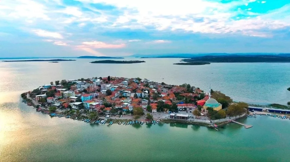
Being dwelled continuously for ages, Gölyazı has a unique feature for being a vicinity which still maintain the tradition distilled from the various hosted civilizations both spatially and economically. Apollonia ancient city, presently Gölyazı, was established on a peninsula which ranges to Lake Apolyont (Uluabat) as a natural dockage and on an island which is connected to the peninsula by means of a bridge. The ancient ruins are densely on the island whereas some ruins also discovered within the peninsula. The ruins of the Apollonia ancient city, starts at the point after departing 3,7 kilometers from the Bursa-İzmir motorway, the traces of the ancient road can be seen on the surface in Deliktaş. ‘Deliktaş’ surrounded by olive trees is presumed to be a construction or a aqueduct. ‘Necropolis’ starting with the ancient roads ranges towards the lake bank where many tomb basins and covers were discovered. The ‘Outer Castle’ called as the ‘Taş Kapı’ by public, was constructed for controlling the narrowest part of peninsula. When the water level rise, this part of the peninsula gets flooded and turns into an island. It’s understood that this castle was 100 meters long and 8,5 meters thick according to the traces. On the western part of the west-east directed walls, there is a bastion in square prism shape with each side 8,5 meters. The bastion was constructed by the stones of the open-air theatre within the vicinity. The island which is currently connected to the peninsula with a bridge was surrounded by castle walls for about 4,5 kilometers long and bastions. Most of these ruins were used as a basement for the new constructions. The bastion at the northeast of the island maintained. All of the stones constituting the bastion were dated to Roman period. The marble architectural structure which consists of 6 pieces of Greek tablets aligned side by side is remarkable. On the upper part of these pieces, fifteen “chopped steer head” are tied to each other with girlants. Over the girlants rosettes with sometimes four sometimes five leaves, wind rose and shield motives were carved. It is known that the Epigraph continues in two pieces on the northern part of the bastion. It was presumed to be written on the city gate in honor of Roman Emperor Hadrian (117-138) who visited Apollonia during the Cyzikos trip but then taken off from there and was used on the bastion for the second time. The ruin known as ‘Simitçi Kale’ is constructed on a rectangular plan. The arch at north maintained. Major part of the walls try to stand still willingly to maintain the old glorious times. The 45X50 meters size ‘Ancient Theatre’ leans to the hillside which is called ‘Gavur Mezarlığı’ in colloquial speech. The cavea and orchestra parts of the theatre are visible. The cavea of 75 meters diameter is presumed to have a capacity of about 4.000 spectators. The architectural parts were removed and used in the construction of the walls. Apollonia is the vicinity with most churches in Bursa and around. Some churches fully maintained whereas only basement ruins left back from some. There is a church basement with 16,40 meters long and 9,20 meters wide near the coastline. The wall thickness is 1,10 meters. Inner parts were separated with white stripes 0,035 meter vertically, 0,015 meter horizontally.
* Hagios (Saint) Panteleiman Church
The church on the peninsula entrance was constructed in the second half of the 19th Century. The walls of the rectangular planned structure were laid by bricks and quarries alternately. Cut stone were used on the exterior wall ranks and window sashes and under fringe molding. The unique wooden building maintained partially. It’s observed that the roof was protected with iron connections apart from the wooden connections. In the church with full four walls, there are also column headings bearing interesting reliefs. Being one of the rare maintained churches in Bursa, the Hagios Panteleiman Church is one of the remarkable samples of Greek classical architecture. The building is planned to serve as a cultural house after the renovation practices started in 2009 were completed by the Municipality of Nilüfer.
* Islands
In Lake Uluabat, apart from the island on which the Apollonia ancient city is located on Gölyazı, there are also historical ruins on Alios (Alyos-Halilbey) and Manastır (Nailbey) islands.
* Alios (Alyos-Halilbey) Island
The island captured by the Ottomans in 1302, subsequently named as ‘Kız Island’, ‘Keşiş Island’, ‘Halilbey Island’. In Alios which mostly confused with Galios/Galyos Island (İmralı) and which is the biggest island on Lake Uluabat, there are ruins from the Byzantine period.
* Apollon Temple
It’s known that the Apollon Temple which named the city, was on Kız Island through the notes and the illustrations of Lé Bas who visited the vicinity in 1800s. Through the researches made within the island and around, the Hellenistic temenos wall in dimensions of 70X50 m which surrounds this area preserve the geographical form and on the western side stepladders entrance in semicircle form was determined. The genuine height of the wall is about 1,5 meters. In respect of the scenery, the island is entirely the holly field of Lord Apollon and he has a temple here. On the eastern side of the wall, mooring blocks were located. Also the column pulleys and bases which are presumed to be parts of the temple, are located outside the temenos wall, within the lake. The magnificent marble walls of the temple ruin within the Kız Island, is worthseeing although they sometimes submerge. According to Dr. Bedri Yalman, the Apollon Temple coined on the money during the Roman Emperor Caracalla who reigned between 198-217 is this temple. Apparently from the relief on the coin, the frontal part of the temple was with 4 columns and triangle frontal. It’s being claimed that the stones of the temple were used in the construction of Haydarpaşa Port.
* Manastır Island (Nailbey Island): The Island of Turkish Robinson
In Lake Uluabat, the second biggest island after Alios Island is the Manastır Island located west of Gölyazı, southeast of Eskikaraağaç Village of Karacabey. Being named as the ‘Happy Island by Gölyazı inhabitants, began being called as the Nailbey Island after Ziya Nail Dölen who was known as the Turkish Robinson during 1940s began living here. Ziya Nail Dölen of whose life is full of mysteries was born in Eskicuma, Bulgaria. According to the stories, he took the hills during the Balkan wars and fought against Bulgarians, and escaped to Paris when the Ottomans recoiled and took higher education about agriculture there. Dölen who came to Turkey and dwelled in Bursa in the early years of Republican period, was outcasted for unknown reasons, bough the island on Lake Uluabat for 2.300 liras in 1940 and began living here. Making friends with the fishermen and the villagers, Dölen was popular for protecting the Byzantine ruins and the environment. When he passed on February 20, 1950 he was buried to Gölyazı Cemetery with the gravestone bearing this epitaph: The grandson of Cumai Balalı Hacı Mehmet Bey and the son of Ziya Bey, dweller of Happy Island, 1886/20 February 1950.
* Hagios (Saint) Constantinos (Helena) Church
In Manastır Island, there are ruins of the Hagios Constantinos (Helena) Church of the Byzantine period. The construction of the building which is one of the oldest sacred buildings of the region is dated as the 9th-10th Centuries. Was considerably restored and renovated by the end of the 18th and the beginning of the 19th centuries. Constructed in form of Closed Greek Cross, the walls of the church were laid by 5 rows of bricks and rough stone. The dome is completely demolished. Visiting the island in the 16th Century, S. Gerlach narrates that the church was dedicated to Saint Constantinos and six or seven monks lived here.
* Theotokia Church
Apart from the Gölyazı, Halilbey and Nailbey islands, there are small islands within the Lake Uluabat as Kerevit Island, Kızadası, Terzioğlu Island and Arifmolla Island. Also within these islands, structural ruins of the Byzantine period are discovered. One of these is ‘Theotokhia’ which is of the Christanity Age buildings. Bilge Umar claims that the name of this church derived from ‘Theotokos’in Hellenic and means ‘god procreant/home of Mary’.
* Gölyazı Wind Mill
The door of the wind mill located in the school garden in Gölyazı Bayır Quarter is southward, currently out of use.
* Gölyazı Primary School
The primary school in Gölyazı nearby the mosque was 4-5 storey. The upper floors of the school was destroyed, the northwestern part of the extant entrance floor is considerably demolished.
* Civil Architecture in Gölyazı
The most common plan types of the dwelling houses within the Gölyazı settlement are; reverse L sofa, side sofa, mid sofa and rarely side T sofa. The buildings on the northeast of the island constituting the Merkez Quarter courtyard houses whereas the ones on southeast are garden houses. The garden houses on the southeastern part attest to the assertions that this half of the island was not inhabited during the ancient ages and the Ottoman period and utilized for agriculture. Particularly during the times when the silkwormbreeding was the main income, the spatial buildings were mostly 4-5 storey. As the silkwormbreeding was abandoned, the upper floors were out of use and thus vertical utilization decreased and storey heights significantly reduced.
* The Crying Plane Tree
The historical plane tree by the bridge which connects the peninsula to Gölyazı Island, is one of the oldest plane trees in Bursa. As of 2010, the 735 year old plane tree bears international monumental tree sign. The plane tree providing 400 meters shadow, is named as the ‘Crying Plane Tree’ for shedding the sap. A fish restaurant and a tea garden is located around the tree. By the efforts of Biologist Mehmet Okatan, General Directorate of Motorways put the monumental tree sign and the ‘Crying Plane Tree’ name plate. The signboard in front of the plane tree bears this poem of Mehmet Okatan: “A plane tree, slanted by the fatigue of the history. But still has hope against all hope, laid as such Afflicted, the leaves are sad, in deep sorrow As an interpreter of the wars, griefs, blind loves Behind a love garden, a rosebud that can not blossom In front, the work of tears in streams, a giant lake.”